Steel Shire Design
GIS Analyst
July 2025 - Present
Steel Shire Design provides mapping and ROW management systems to companies planning energy infrastructure projects such as pipelines, solar fields, or wind farms. As a GIS Analyst, I manipulate various formats of spatial data to display proposed facilities and land required for project completion. In addition to my technical GIS duties, I provide customer support for solutions and create documentation of team standards of practice.
From a technical standpoint, I perform data analysis or create maps based on specific client needs and communicate with various stakeholders to ensure project success. I maintain, edit, and publish large datasets using ArcGIS Server and ensure these services are optimized for client-side performance. I perform spatial analyses using project data to provide insight for client planning and project management.
Colorado Governor's Office of Information Technology
GIS Analyst
October 2023 - August 2024
Building on my workflows from my position as a Technician, some of my tasks include leading the onboarding and training process for our statewide imagery service, create ArcGIS Hub sites for partner organization needs, and creating, editing, and publishing data using an ArcGIS Enterprise environment.
As a GIS Analyst, I worked with other departments at the State of Colorado to collect and visualize data related to their projects. I then developed Experience Builder applications to host and distribute information to state-wide audiences. I played a major role in documentation of GIS team workflow documentation and clean-up efforts of an existing ArcGIS Online environment.
Examples of applications, documentation, and trainings I have created in this position can be found on the Applications and Skills pages.
GIS Technician
December 2022 - October 2023
In this position, I worked on a variety of projects both collaboratively and individually. For example, I worked with colleagues to gather, process, and publish aggregate statewide datasets for parcels and addresses. Individually, I have worked with staff at partner agencies to coordinate and build various types of web applications using the Esri software suite. Additionally, I helped develop best practices and detailed documentation for several team workflows and have written and lead training on a range of GIS topics. For example, I lead trainings on our statewide imagery service to get users on-boarded to the service to access the data.
Colorado Mountain College
GIS Lab Assistant
August 2023 - May 2024
During the 2023-2024 academic year, I work as a GIS Lab Assistant at the Steamboat Springs campus of Colorado Mountain College. I assisted in-person and remote GIS students in the Introduction to Geographic Information Systems, GPS for GIS, Cartography, Remote Sensing, and Intermediate GIS courses with GIS labs and projects.
Colorado Department of Transportation
GIS Intern
March 2022 - December 2022
In March of 2022, I was hired as an intern at the Colorado Department of Transportation to help process, update, and maintain the state’s inventory of Right-of-Way as a spatial dataset. CDOT is one of the only DOTs to have this dataset. Right-of-Way (ROW) and real property is one of a Department of Transportation’s largest and most important assets, and having a spatial representation of this data makes it significantly more accessible for keeping inventory and performing analysis. To read more about this project, visit this Esri blog: GIS Allows Colorado Department of Transportation to Capture the Full Value of Their Properties.
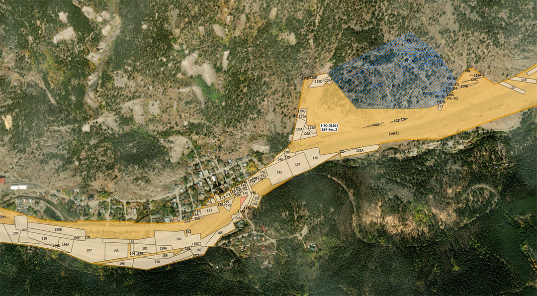
Parcel representation of the Right-of-Way extent including parcels and easements along Interstate 70.
While working on the ROW project, I helped initiate a life cycle process for property data, collaborated with CDOT’s Property Management group to create a parcel tracking database, and used ArcGIS Pro to georeference Right of Way plans and digitize real property data using a versioned database in ArcGIS Enterprise. I spent time developing a detailed processing manual for future real property GIS workflows and performing periodic QA/QC on the ROW data.
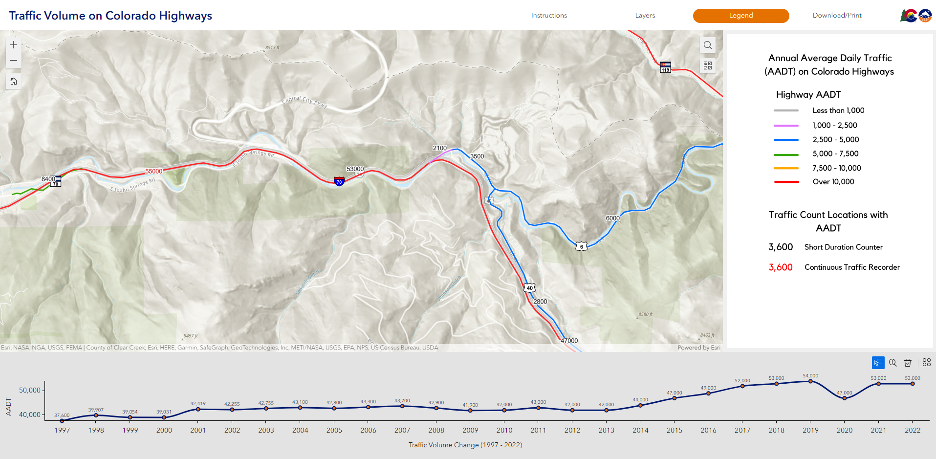
Additionally, I developed Esri web applications on various topics for other organizational use such as a bridge condition dashboard and an interactive traffic volume map to illustrate temporal traffic volume data on Colorado highways.